  Google has released more than a quarter-century of images of Earth taken from space working with the U.S. Geological Survey (USGS), NASA and TIME.
This is for the first time that these images built from millions of satellite images and trillions of pixels have been compiled into an interactive time-lapse experience.
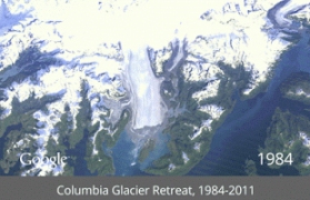
One can explore this global, zoomable time-lapse map as part of TIME's new Timelapse project and view stunning phenomena such as the sprouting of Dubai’s artificial Palm Islands, the retreat of Alaska’s Columbia Glacier, the deforestation of the Brazilian Amazon and urban growth in Las Vegas from 1984 to 2012:
The images were collected as part of an ongoing joint mission between the USGS and NASA called Landsat. Their satellites have been observing earth from space since the 1970s, with all of the images sent back to Earth and archived on USGS tape drives that look something like this example (courtesy of the USGS).
Google said that it started working with the USGS in 2009 to make this historic archive of earth imagery available online. Using Google Earth Engine technology, we sifted through 2,068,467 images—a total of 909 terabytes of data to find the highest-quality pixels (e.g., those without clouds), for every year since 1984 and for every spot on Earth. We then compiled these into enormous planetary images, 1.78 terapixels each, one for each year.
“As the final step, we worked with the CREATE Lab at Carnegie Mellon University, recipients of a Google Focused Research Award, to convert these annual Earth images into a seamless, browsable HTML5 animation. Check it out on Google’s Timelapse website”, it said in a blog.
For best mobile phone deals: http://shopping.telecomtiger.com/
For latest updates on facebook: http://www.facebook.com/pages/TelecomTiger/429104257149437 |